


The Wadden Sea World Heritage is of outstanding importance for birds. Here the birds enjoy a high availability of food. Also, some of the islands and high sands lack mammalian predators and human disturbance. Almost one million ground-breeding birds belonging to 31 species use the site. More than 25 % of the European populations of the Eurasian spoonbill, avocet, gull-billed tern and sandwich tern breed in the Wadden Sea Region.
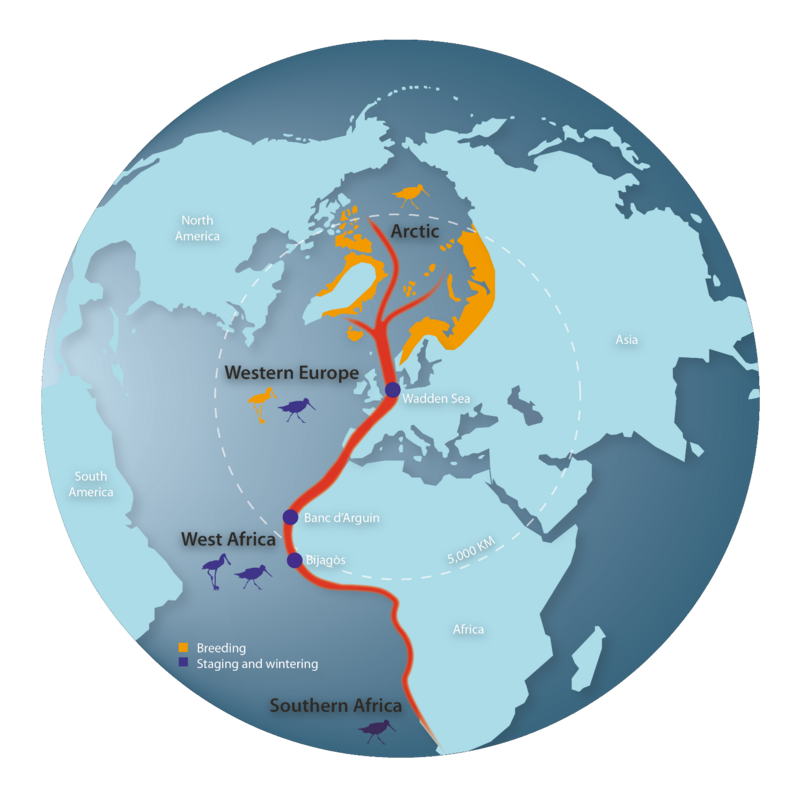
According to the Ramsar Convention the Wadden Sea is essential for the existence of at least 52 populations of 41 migratory waterbird species that use the East Atlantic Flyway. For example, almost the entire population of dark-bellied brent goose and the entire European and West-Russian population of dunlin use the Wadden Sea during certain periods of the annual cycle. Only here do they find enough food to complete their journeys, covering thousands of kilometres.
Many birds use the Wadden Sea only briefly; others do so for several months and use the area to gain enough energy for further migration. Other species spend the whole winter in the area. Therefore, the annual total number of birds using the area (up to 12 million) is much higher than the total numbers present at any one time. The Wadden Sea is one of the most significant sites for coastal birds in the world.
The Joint Monitoring Migratory and Breeding Bird groups (JMMB, JMBB) are composed of national coordinators responsible for trilateral bird count coordination, breeding success monitoring, assessment and reporting. The results are published in biannual trilateral trend reports.

The designation as World Heritage site by UNESCO is a recognition of the Wadden Sea’s crucial importance and responsibility for the conservation of migratory birds on a global scale. Upon request by UNESCO, the Trilateral Wadden Sea Cooperation (TWSC) aims to strengthen cooperation on management and research activities with States Parties on the African Eurasian Flyways, which play a significant role in conserving migratory species along these flyways. The Wadden Sea Flyway Initiative (WSFI) was launched in 2012 to implement this request.
The Initiative envisions that
“migratory birds find lasting refuge along the East Atlantic Flyway from northern breeding areas to their key Wadden Sea stopover and to the African coastline, and inspire and connect people for future generations”.
The WSFI focusses on capacity building and promotes monitoring of birds along the East Atlantic Flyway (EAF). Regional and local capacity building and training workshops, management plans and education material, as well as concrete facilities like boats and bird observatories form measures to improve management of habitats and conservation of migratory water birds along the African Atlantic seaboard. In the winters of 2014 and 2017, the WSFI partners successfully conducted total counts of migratory birds with comparable data sets. The results give an overview and a status of Wadden Sea migratory bird populations along the EAF.
For more information on the Wadden Sea Flyway Initiative, visit flyway.waddensea-worldheritage.org
| Video Download | DK | DE | EN | FR | NL | PT |
